Lake of the WeekBluffs and Water
8 Ways to Spend a Day at Devil's Lake
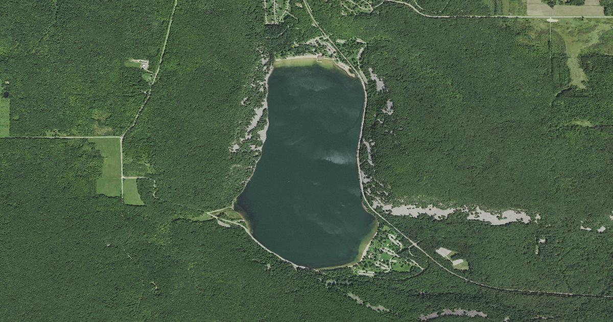
"Devil's Lake" is a mistranslation. The Ho-Chunk name for this water is Tee Wakącąk, which the Wisconsin DNR renders as "Tee Wakacak, in the Ho-Chunk language, closely meaning Sacred Lake." European settlers read it through a Christian frame, and the wrong version is the one that stuck. The tradition attached to the lake involves a protective catlike water spirit, something like a lynx or a water panther. Nothing in the original carries a negative sense.
The second thing to know, before you set an alarm, is that the DNR expects this park to fill. Its crowding page says parking lots often fill before 9 a.m. on weekends and holidays from May through October, and that access to the park may be temporarily restricted until congestion lessens. The squeeze lands on the north and south shore picnic areas and on the West Bluff, East Bluff, Tumbled Rocks, Balanced Rock and Devil's Doorway trails. The DNR's own workaround is to park at Steinke Basin, Roznos Meadow or another Ice Age Trail lot and walk in.
Eight things below, roughly in the order you would hit them: a lake with no outlet, a bear and a panther shaped in earth, the stone steps the Civilian Conservation Corps cut into the bluff, the climbs the park declines to endorse, what it costs to rent a boat and which landing is closed this month, the freight line that still runs the shore, and two supper clubs.
Stand on a lake that has no way out
Devil's Lake State Park, Baraboo, Sauk County
This is not a lake basin. It is a river gorge with both ends stoppered. An ancient river cut the Devil's Lake Gap and the Lower Narrows through the Baraboo Hills, and then, in the DNR's words, "the Wisconsin Glacier rerouted the ancient river(s) elsewhere and deposited dams of rocks and earth at the two open ends of the Devil's Lake Gap." That was roughly 15,000 years ago. What is left sits, as the geology page puts it, between two glacial plugs in an abandoned valley.
There is no natural outlet. The DNR says the lake "is spring-fed and varies in depth from 40 to 50 feet," and what water leaves does so by evaporation and seepage. The walls are the older story: bluffs standing 500 feet above the water, Baraboo quartzite the DNR dates to about 1.6 billion years and calls one of the most ancient rock outcrops in North America.
Before you go: Vehicle admission, at DNR rates effective Aug. 19, 2025 (dnr.wisconsin.gov/topic/parks/admission): $13 a day on a Wisconsin plate, $16 out of state, $28 for a resident annual sticker, and another $5 for anyone who uses the park before paying.
Look for the bear and the panther near the shore
The Claude Group and other mound groups, Devil's Lake State Park
The park holds the largest concentration of effigy mounds in Sauk County, according to its visitor guide: bear, lynx — glossed there as the water spirit — bird, plus linear and conical mounds, built in the Late Woodland period and dated by the guide to 1400 to 750 B.P., roughly 1,400 to 750 years ago. The Claude Group, nearer the shore, holds a bear, a panther and two linear mounds. Both the mound roster and the tradition behind the Ho-Chunk name turn on a catlike water spirit.
Many of the mounds were plowed under or built over as settlement spread; early farmers reported "at least 25 on our land." Mapping and study began in earnest in the 1920s, and surviving mounds were later restored using survey records and historical examples. The guide says they hold deep cultural and spiritual significance for the Ho-Chunk and 19 other culturally associated American Indian nations.
Before you go: The DNR runs a guided program, "Burial Mounds and Effigy Earthworks of Devil's Lake State Park." The listed session is Wednesday, Aug. 5, 2026, 6 to 8 p.m. — two days out, per the DNR's own event listing (dnr.wisconsin.gov/events/126851), checked Aug. 2.
Take the stone steps a 1930s work camp cut
East Bluff and West Bluff trails, Devil's Lake State Park
From 1934 to 1941 about 200 Civilian Conservation Corps men lived in a camp of roughly 15 buildings inside the park, alongside National Park Service personnel and U.S. Army officers. The DNR's history page says they "built trails in some of the most rugged parts of the park," guided visitors onto the bluffs, built tables, signs and benches, built a reservoir, relocated roads and patrolled the bluffs as fireguards. They quarried local quartzite for the park headquarters, the Rock Elm shelter and the ranger headquarters, and laid the stone steps that still carry hikers to the top. One of the Most Difficult trails is simply called C.C.C.
The DNR rates six bluff trails Most Difficult and is specific about why. Balanced Rock is 0.4 miles of what it calls a steep climbing trail more like an uneven rocky staircase, with the rock itself about 100 feet off the path. East Bluff runs 1.7 miles with many stone steps at the north end, past Elephant Rock and Elephant "Cave." Its opposite number, West Bluff, is 1.4. Tumbled Rocks, a mile long and the trail the DNR calls its most popular, asks none of that.
Before you go: Of the park's 29 miles of trail, about 1.5 miles is accessible. The easier ground the DNR publishes is the Grottos, 0.7 miles of level gravel, and the Steinke Basin and Johnson Moraine loops at 2.4 and 2.8 miles. Three shorter trails carry the Most Difficult rating anyway — Devil's Doorway at 0.1 miles, Potholes and C.C.C. at 0.3 — and Sauk Point, 4.5 miles, reaches the highest point in the Baraboo Hills.
Climb rock the park will not vouch for
The quartzite on both bluffs
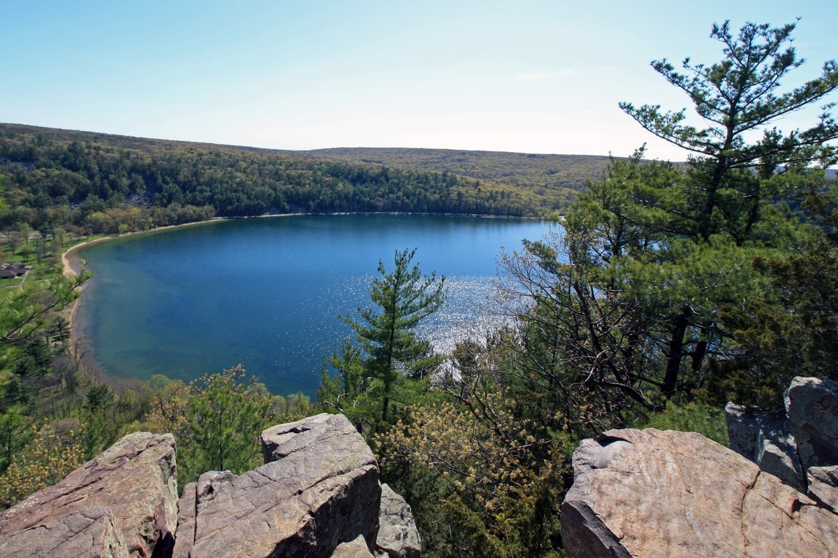
The view from the bluff, over the quartzite the trails climb through. jcantroot via Wikimedia Commons (CC BY 2.0) The University of Wisconsin Press calls Devil's Lake the most popular rock-climbing area in the Midwest, and the standard guidebook — Swartling and Mayer's Climber's Guide to Devil's Lake, third edition, UW Press, 2008 — describes nearly 1,800 climbs on the quartzite. That count is the publisher's. The park keeps none of its own.
The DNR's stated position is unusual for a park this busy: "The park neither prohibits nor promotes rock climbing in the park." No permits are issued, and particular areas or routes are not reservable. Many people climb and boulder here, the agency says, but the park is not maintained for rock climbing, climbers may encounter loose rocks, and you do it at your own risk. Every year there are some accidents and injuries, rarely involving trained and experienced climbers; the DNR attributes most of them to inexperience or alcohol.
Before you go: Nothing here is bookable: the DNR issues no permits and reserves no routes. Climbing schools operate in the park, but the agency says it does not maintain information about these private businesses, so vetting one falls to the climber.
Paddle it, but leave the gas motor at home
Two beaches and two no-fee landings, north and south shores
Two beaches sit at opposite ends of the lake, 3,300 feet of sand in total, and the DNR is explicit that lifeguards are not provided. Only electric motors are allowed on the water. Two no-fee boat landings serve the lake, one on the north shore near the Chateau and one along Park Road. Scuba diving is permitted, dive flags required, and the instruction is never to dive alone.
Rentals run out of the North Shore Chateau and the South Shore concessions building. The Chateau at the north end hosted big bands through the 1930s, per the park's history page. The concession page, dated July 9, 2025, lists 10 a.m. to 6 p.m. daily, a $100 refundable deposit against a valid photo ID, last boat out one hour before closing and all boats back by 5:45 p.m. By the hour: $17 single kayak, $25 double, $22 paddleboard, $35 pontoon paddle boat. North Shore Beach has an accessible beach mat, a beach wheelchair can be checked out at the Chateau, and the rental program keeps an adaptive kayak.
Before you go: The north shore boat launch and parking lot have been closed since Monday, July 6 for dredging, through approximately August 11, 2026, per a DNR notice updated June 16. The south shore launch stays open. Re-check before you tow anything: the DNR also warns that facility projects beginning in 2026 may take restrooms, shower buildings, parking lots, rental shelters and boat launches out of service at times.
Stay off the tracks the resort trade arrived on
The active rail line along the lake
Devil's Lake was a resort before it was a park. The first hotel went up in 1866, the railroad was finished in 1873, and after that the Kirkland Resort, the Minniwauken House, the Lake View Hotel and the Messenger Hotel took guests straight off the trains. Two side-wheel steamers, the Capitola and the Minniwauken, ran excursions on the water. The state park came in 1911, Wisconsin's third after Interstate in 1900 and Peninsula in 1909. A golf course operated from 1922 to 1961; the Quartzite Campground sits on that ground now. Annual visits went from 100,000 in 1919 to 200,000 in 1924 and over a million by 1952.
The railroad never left. The line along the lake is an active freight route operated by the Wisconsin & Southern Railroad. Around 8 p.m. on Sunday, May 28, 2023, three cars derailed inside park boundaries and two of them spilled coke, a coal-derived manufacturing product, as reported at the time by Wisconsin Public Radio. Officials reported no injuries, no hazardous material and no risk to the public or the environment.
Before you go: Hikers may cross the line only at designated locations — this is working freight, not a rail-trail. The park's current annual visitation is one number we are not printing: the DNR's crowding page and its own history page do not agree.
Take a beeper instead of a reservation
Supper clubIshnala Supper Club, S2011 Ishnala Rd, Lake Delton — roughly 13 miles north, inside Mirror Lake State Park
The Hoffman Brothers built Ishnala in 1953, on ground the club's own history says the Winnebago — the Ho-Chunk — used as ceremonial land. A log-cabin trading post went up on the site in 1826 and the Coleman family put a house here in 1909. "In the language of the Winnebago Indian," the club writes, "Ishnala means 'By Itself Alone.'" Live Norway pines still grow up through the roof. The dining room floor is 76 tons of flagstone out of the nearby quarry, and the Arrowhead Bar is built in the shape of an arrowhead.
Robert Prosser started as a busboy for the Hoffmans in 1973, at the Hoffman House in Wausau, and came to Ishnala full time in 2010. The house measures its year in cocktails: "We don't count the minutes, we count the Old Fashioneds," 93,478 of them in 2021. That drink is the signature, made with Ishnala Brandy or Ishnala Single Barrel Bourbon. Travel Wisconsin calls the signature the Chief Ishnala; on Ishnala's own menu that is a different cocktail. "We do not take reservations" — you take a beeper and explore the grounds while you wait.
Before you go: The bar opens 3:30 p.m. Monday through Friday and 2:30 p.m. Saturday and Sunday; dining starts at 4 on weekdays and 3:10 on weekends. Live music on the beach runs 4 to 7 daily, and the homepage bills 2026 as the 73rd season. Arrive by the entrance drive or on foot, 2.2 miles up the Ishnala Trail. Dress code, in full: please no swimsuits.
Eat Friday haddock in the hall where the Maiers had their wedding dance
Supper clubDorf Haus Supper Club, 8931 County Highway Y, Roxbury — about 25 miles southeast, three miles from Sauk City
Vern and Betty Maier married on Jan. 28, 1950, and held their wedding dance in Brownie Breunig's tavern and dance hall in Roxbury. Nine years later, in 1959, they bought the building. Vern used the hall as a woodworking shop for his construction business at first and ran only the tavern; within a few years it was a supper club selling one-dollar family-style all-you-can-eat fish and chicken dinners, and then it was the Dorf Haus. Vern and Betty both died in 2012. Two of their children, Monte and Rebecca, run it now.
The menu runs German and American side by side — wiener schnitzel, sauerbraten, rouladen and pork shank next to prime rib, barbecued ribs and the family-style chicken. The Friday fish fry is haddock with homemade fritters, a choice of German potato salad, fries or a baked potato, and coleslaw. The all-you-can-eat family-style fish was dropped around 2020, so Friday comes as a single plate now. There is live polka in the back bar.
Before you go: The Sauk Prairie chamber lists Wednesday through Sunday evenings, closed Monday and Tuesday, but that is a directory listing rather than the restaurant's own page, and we found no published reservation policy — call 608-643-3980 for the current schedule before you drive out.
The DNR counts 423 campsites across Quartzite, Northern Lights and Ice Age, plus nine group sites accommodating 460 campers, and takes reservations up to 11 months ahead. Two gaps we would rather name than paper over: we did not verify Ishnala's food menu or whether it runs a Friday fish fry, so we have not described either, and we have not yet cleared the Ho-Chunk spelling above with the Ho-Chunk Nation's Language Division. Everything else here is checked against the source named under it and dated, because closures and hours move. Where the best source we could reach was a chamber listing or a magazine rather than the operator's own page, we say so on the line. If we have something wrong, tell us and we will fix it.