LakeList
FavoritesStateWisconsin
Clara Lake depth map
Interactive depth contours
Interactive depth contours for Clara Lake in Polk County, Wisconsin, derived from LakeList depth model survey data. Pan the map, inspect contour depths, or open the 3D underwater view.
71max depth feet
22mean depth feet
56surface acres
14mapped depth contours
Clara LakePolk County, WI
Contours load with map
Interactive depth contours5-foot typical interval · Modeled depth estimate · Not a survey · Not for navigation
Source: LakeList depth modelmedium confidence · QA passed · Select a contour to inspect its mapped depthModeled depth estimate: contours computed from the lake's shoreline shape and its documented 71-ft maximum depth (depth grows with distance from shore, calibrated to the documented mean depth where available). This is a smooth mathematical model, not a survey - real holes, bars, and drop-offs will differ. Community sonar (C-MAP Genesis) overlays where recorded. Not for navigation.Historical Wisconsin DNR maps
Clara Lake depth maps
1 converted map sheet. These historical surveys are not for navigation.
Navigable depth map
Clara Lake · sheet 1
Pan, zoom, and inspect the converted Wisconsin DNR historical map image in the browser. Historical survey — not for navigation.
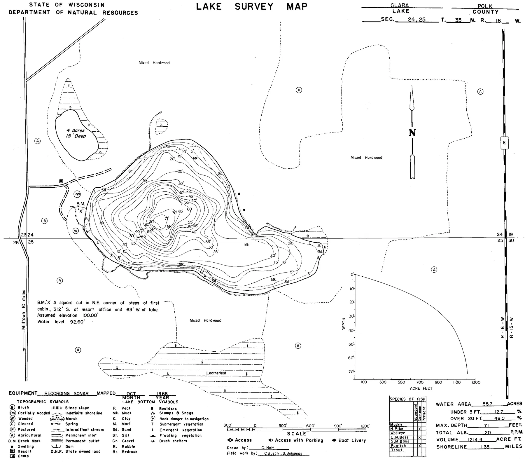
Source: Wisconsin DNR · WBIC 2457300 · image navigation only; spatial alignment pending · Historical lake maps are not for navigation.
Source: Wisconsin Department of Natural Resources. Converted for browser access with source URLs, checksums, and retrieval dates retained. Historical lake maps are not for navigation.
Depth FAQ
How deep is Clara Lake?
Clara Lake is 71 feet deep at its deepest point and averages about 22 feet, according to Wisconsin DNR records.
Is there a free depth map of Clara Lake?
Yes. LakeList publishes a free interactive depth contour map of Clara Lake at a typical 5-foot interval, with an optional 3D underwater view, derived from LakeList depth model survey data.
Where does the Clara Lake depth map come from?
The interactive depth contours are derived from LakeList depth model. Each contour set passes a visual QA review against the source document before it is published. The depths are a modeled estimate calibrated to the lake's documented maximum depth - not a survey, and not for navigation.