LakeList
FavoritesStateWisconsin
Upper Kelly Lake
Enhanced dataHistorical depth chart
Upper Kelly LakeWaukesha County, WI
Historical source depth chart available1 converted source DNR map sheet can be panned and zoomed in the browser. Interactive contours stay hidden until visual QA passes. Historical survey — not for navigation.
View browser depth chartLakeList assistant
Plan your lake day
Fishing spots, food, lodging, marinas, and rentals around Upper Kelly Lake.
Start here
Fishing forecast
Best windows for Upper Kelly Lake
Weather-based planning built from the National Weather Service hourly forecast near this lake.
Loading latest forecast…
Checking wind, precipitation, and near-term weather windows.
Water temperature
Upper Kelly Lake water temperature today
Modeled surface-temperature estimate built from seasonal climate, lake depth, and live National Weather Service air temperatures near this lake.
76°FPeak summer
Seasonal estimate. Checking current National Weather Service air temperatures…
Warmest water of the year. Fish hold deeper or feed in low light; swimming and watersports are at their best.
Estimates are modeled, not measured. Actual temperatures vary with depth, wind mixing, and recent weather — verify conditions before swimming, boating, or heading onto ice.
DNR water check
Water quality quick take
Historical volunteer-monitoring record for this lake.
Last sampled Sep 2024Volunteer monitoring 2009–2024
DNR volunteers monitored this lake for about 15 years, ending in 2024. Its final monitored summers showed murky water (~2.3 ft Secchi) in 2020, elevated algae (chlorophyll ~15 µg/L) in 2009, and moderate nutrients (phosphorus ~26 µg/L) in 2024. After 2 years without samples, these readings describe the lake as it was, not as it is.
| Year | Secchi | Chlorophyll-a | Total phosphorus |
|---|---|---|---|
| 2020 | 2.3 ft (7) | — | — |
| 2019 | 2.6 ft (4) | — | — |
| 2018 | 3.6 ft (6) | — | — |
| 2017 | 4.3 ft (7) | — | — |
| 2016 | 4.0 ft (6) | — | — |
| 2015 | 6.2 ft (4) | — | — |
Upper Kelly Lake - Deep HoleStation 683376
Historical record only — no current water-quality data exists for this lake. LakeList verified 2026-07-12.Official Wisconsin information
Plan with DNR sources
LakeList links to the authoritative record so you can verify maps, rules, and current notices before leaving.
Historical DNR depth maps1 converted map sheetView DNR depth mapHistorical map · not for navigationFishing regulationsVerify current seasons, limits, and restrictionsOfficial DNR lake pageFacts, advisories, boating, and water qualityWater quality reportsMonitoring stations, clarity, and DNR reportsInvasive speciesVerified, observed, and historical AIS recordsBoating ordinancesLocal slow-no-wake and water-use restrictionsFish consumption advisoriesStatewide and waterbody-specific health guidance
Historical depth maps are not for navigation. Verify regulations and access at the official source before your trip.
Historical Wisconsin DNR maps
Upper Kelly Lake depth maps
1 converted map sheet · 1 map-aligned. These historical surveys are not for navigation.
Navigable depth map
Upper Kelly Lake · sheet 1
Pan, zoom, and inspect the converted Wisconsin DNR historical map image in the browser. Historical survey — not for navigation.
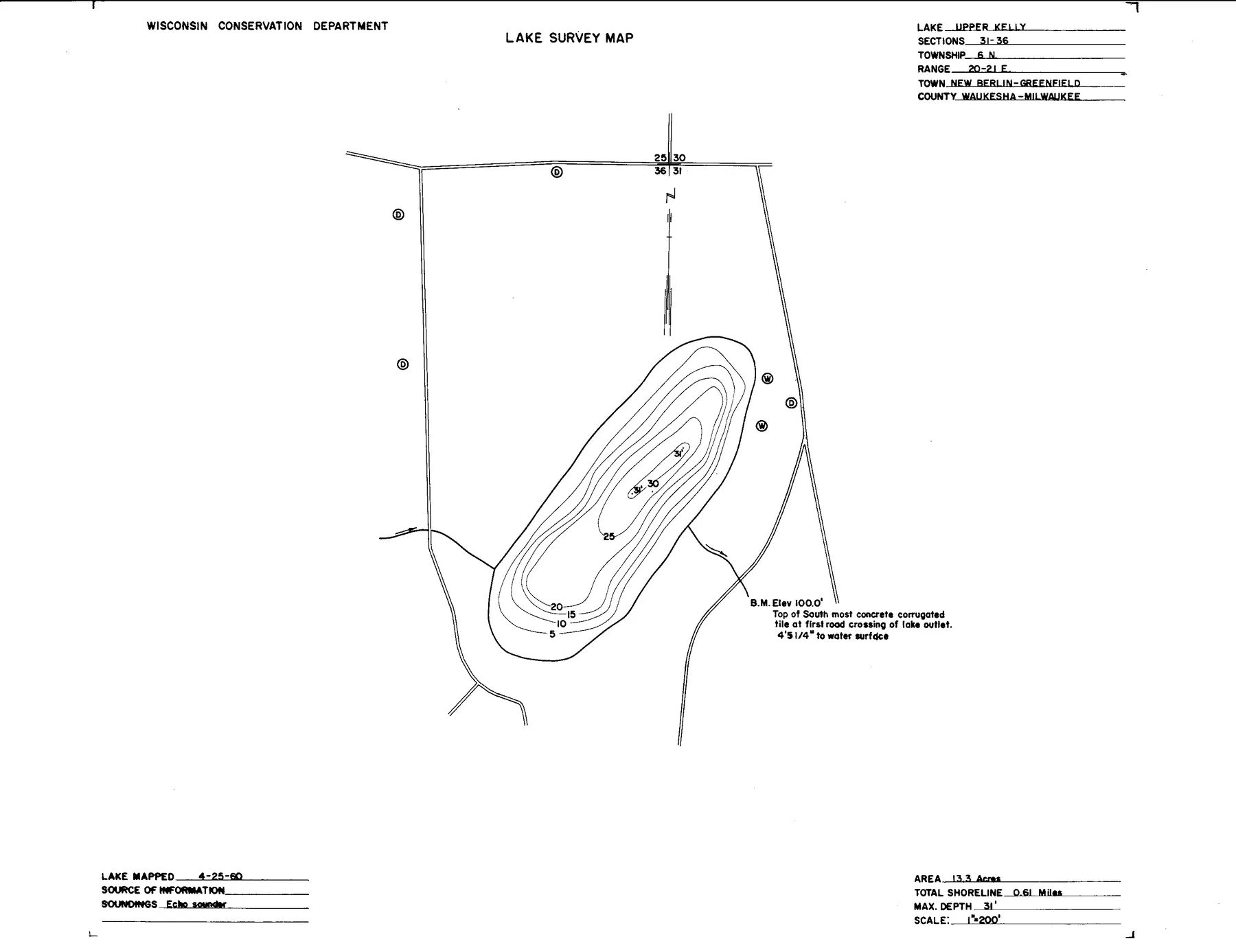
Source: Wisconsin DNR · WBIC 7100 · map alignment passed · Historical lake maps are not for navigation.
Source: Wisconsin Department of Natural Resources. Converted for browser access with source URLs, checksums, and retrieval dates retained. Historical lake maps are not for navigation.
Wisconsin DNR · 2026–2027 season
Lake-specific fishing regulations
Rule text published by the DNR for this waterbody, cached by WBIC and verified 2026-07-12.
All species
This lake may be in more than 1 county. Follow the trolling regulations for the county in which you are fishing. A list of counties and waters that allow motor trolling with 3 hooks, baits, or lures per angler can be found at http://dnr.wi.gov/topic/fishing/questions/troll.html. All other waters allow motor trolling with 1 hook, bait or lure per angler, and no more than 2 hooks, baits, or lures per boat.
Catfish
Season Dates: Open All Year. No minimum length limit and the daily bag limit is 10.
Cisco and whitefish
Season Dates: Open All Year. No minimum length limit and the daily bag limit is 10.
Lake sturgeon
Season Dates: Closed. No fishing allowed.
Largemouth and smallmouth bass
Season Dates: May 2, 2026 to March 7, 2027. The minimum length limit is 14" and the daily bag limit is 5.
Muskellunge and hybrids
Season Dates: May 2, 2026 to December 31, 2026 on open water. The minimum length limit is 40" and the daily bag limit is 1.
Northern pike
Season Dates: May 2, 2026 to March 7, 2027. The minimum length limit is 26" and the daily bag limit is 2.
Paddlefish
Season Dates: Closed. No fishing allowed.
Panfish
Season Dates: Open All Year. No minimum length limit and the daily bag limit is 25.
Rock, yellow, and white bass
Season Dates: Open All Year. No minimum length limit and the daily bag limit is unlimited.
Rough fish
Season Dates: Open All Year. No minimum length limit and the daily bag limit is unlimited.
Shovelnose sturgeon
Season Dates: Closed. No fishing allowed.
Trout and salmon
See Trout regulations layer.
Urban waters gamefish
This waterbody is not considered an urban water, Urban Waters Gamefish regulations do not apply.
Walleye, sauger, and hybrids
Season Dates: May 2, 2026 to March 7, 2027. The minimum length limit is 18" and the daily bag limit is 3.
Regulations can change. The official DNR page controls; verify seasons, boundaries, bag limits, and emergency rules before fishing.
13surface acres
31max depth feet
0public access points
42.9412, -88.0699latitude, longitude
Access
Public access points
No mapped access points yet
LakeList has not matched a public launch, park, or shoreline access point for this lake yet.
Nearby
Trip-planning places
No nearby trip-planning places yet
Fishery
Notable species
PanfishLargemouth Bass
Wisconsin DNR stocking
Fish stocking history
The latest published year is 2024, when 580 fish were recorded across 4 entries.
2024
Black CrappieUnspecified · Yearling
1605.0 in average
2024
BluegillUnspecified · Yearling
1604.0 in average
2024
Channel CatfishUnspecified · Yearling
1009.0 in average
2024
Yellow PerchUnspecified · Yearling
1605.0 in average
2021
Northern PikeMud Lake - Madison Chain Of Lakes · Large Fingerling
538.3 in average
2019
Northern PikeMud Lake - Madison Chain Of Lakes · Large Fingerling
1408.4 in average
2018
Northern PikeMud Lake - Madison Chain Of Lakes · Large Fingerling
1279.3 in average
2017
Northern PikeMud Lake - Madison Chain Of Lakes · Large Fingerling
229.0 in average
2016
Northern PikeMud Lake - Madison Chain Of Lakes · Large Fingerling
308.9 in average
2015
Northern PikeMud Lake - Madison Chain Of Lakes · Large Fingerling
208.8 in average
2014
Northern PikeMud Lake - Madison Chain Of Lakes · Large Fingerling
269.1 in average
2013
Northern PikeMud Lake - Madison Chain Of Lakes · Large Fingerling
1910.0 in average
Depth FAQ
How deep is Upper Kelly Lake?
Upper Kelly Lake is 31 feet deep at its deepest point, according to Wisconsin DNR records.
Is there a free depth map of Upper Kelly Lake?
Yes. 1 scanned Wisconsin DNR lake survey map sheet is free to view and zoom on LakeList. These historical surveys are not for navigation.
Where does the Upper Kelly Lake depth map come from?
The map sheets are converted from official Wisconsin DNR lake survey documents, with the source URL, checksum, and retrieval date retained for every sheet. Historical surveys are not for navigation.
Trust and freshness
Where this lake data comes from
Wisconsin DNR Lake Mapsname, coordinates, county, source identifiers
LakeList record updated 2026-07-14
Keep exploring