LakeList
FavoritesStateWisconsin
Silver Lake
Enhanced dataInteractive depth contours
Silver LakeManitowoc County, WI
Contours load with map Access
Interactive depth contours5-foot typical interval · Modeled depth estimate · Not a survey · Not for navigation
Source: LakeList depth modelmedium confidence · QA passed · Select a contour to inspect its mapped depthModeled depth estimate: contours computed from the lake's shoreline shape and its documented 43-ft maximum depth (depth grows with distance from shore, calibrated to the documented mean depth where available). This is a smooth mathematical model, not a survey - real holes, bars, and drop-offs will differ. Community sonar (C-MAP Genesis) overlays where recorded. Not for navigation.LakeList assistant
Plan your lake day
Fishing spots, food, lodging, marinas, and rentals around Silver Lake.
Start here
Fishing
Fishing at Silver Lake
Fishery
Notable species
Northern PikePanfishLargemouth Bass
Angler reports · Fishbrain
What anglers catch here
Anglers have logged 165 catches on Silver Lake via Fishbrain — none in the last 30 days.
Latest reported catch: May 31, 2026
Most-reported species
- Largemouth bass
- Northern pike
- Bluegill
- Black bullhead
- Pumpkinseed
- Yellow perch
Show 3 more species
- Green sunfish
- Yellow bullhead
- Walleye
29 of the 165 logged catches didn’t name a species and aren’t listed above.
Seasonality
All fishOf the 165 logged catches, 123 carry a month and 118 carry a year; the charts cover those.
2022 had the most reports (30).
Counts reflect reporting activity, not fish populations. Waterbody location is provider-level; exact spots and angler details aren’t shown.
Fishery details for this lakeExplore this area on FishbrainWisconsin DNR fisheries survey
Fish population survey
Structured LakeList extraction from the 2023 DNR fisheries survey. Population estimates, density, and catch-rate indices use different units, methods, and scopes, so each value is presented in its original form rather than normalized against a different measure.
Survey indicatorsValues keep their source unit and method; unlike measures are not scaled or compared.
Management contextLake-specific 2023 spring fyke-net and spring electrofishing assessment. Counts, CPUE, size indices, growth subsamples and the adult-pike estimate retain their distinct methods.
DNR found that Silver Lake's fishery had recovered well from prior restoration and winterkill, with high northern-pike and black-crappie abundance, moderate walleye and largemouth-bass abundance, and increasing bluegill abundance.
- The northern-pike table distinguishes 264 total captured from 263 used in the population-estimate row; both are preserved with distinct labels and scopes.
- The page-5 carryover header incorrectly says White Clay Lake; no identity or metric value is taken from that stray header.
- Historical trend values and stocking rows remain context rather than current survey observations.
Black crappie
533 fishTotal captured · p. 317.8 fish/net-nightFyke-net CPUE · p. 33.4 inchesminimum captured length · p. 310.8 inchesmaximum captured length · p. 3
Bluegill
817 fishFyke-net catch · p. 427.2 fish/net-nightFyke-net CPUE · p. 43.9 inchesFyke net minimum captured length · p. 48.1 inchesFyke net maximum captured length · p. 4
Largemouth bass
53 fishTotal captured · p. 323 fish/mileElectrofishing CPUE · p. 35.1 inchesminimum captured length · p. 318.3 inchesmaximum captured length · p. 3
Northern pike
264 fishTotal captured · p. 28.8 fish/net-nightFyke-net CPUE · p. 213.1 inchesminimum captured length · p. 232.4 inchesmaximum captured length · p. 2
Walleye
55 fishTotal captured · p. 21.8 fish/net-nightFyke-net CPUE · p. 218 inchesminimum captured length · p. 223.9 inchesmaximum captured length · p. 2
Yellow perch
137 fishTotal captured · p. 44.6 fish/net-nightFyke-net CPUE · p. 44.4 inchesminimum captured length · p. 49.8 inchesmaximum captured length · p. 4
2023 Comprehensive Fish Survey Summary Report: Silver Lake, Manitowoc CountyMatched by exact wbic name county · WBICs 67400 · verified 2026-07-19Wisconsin DNR fisheries survey report; LakeList operator documented permission to leverage this report with source attribution.
Wisconsin DNR stocking
Fish stocking history
The latest published year is 2025, when 364 fish were recorded across 1 entry.
2025
WalleyeLake Michigan · Large Fingerling
3648.0 in average
2023
WalleyeLake Michigan · Large Fingerling
3638.0 in average
2022
WalleyeLake Michigan · Yearling
4058.3 in average
2020
Largemouth BassUnspecified · Large Fingerling
1,8102.3 in average
2019
BluegillUnspecified · Large Fingerling
8,8330.5 in average
2019
Largemouth BassUnspecified · Large Fingerling
1,8122.7 in average
2019
Northern PikeMud Lake - Madison Chain Of Lakes · Small Fingerling
2,0632.7 in average
2019
WalleyeRock-Fox · Small Fingerling
4,7491.8 in average
2018
BluegillUnspecified · Large Fingerling
11,2001.3 in average
2018
Largemouth BassUnspecified · Large Fingerling
1,8052.2 in average
2017
Largemouth BassUnspecified · Large Fingerling
1,8122.1 in average
2017
WalleyeMississippi Headwaters · Small Fingerling
2,5391.7 in average
Showing the 12 most recent records from 25 published entries.
Wisconsin DNR · 2026–2027 season
Lake-specific fishing regulations
Rule text published by the DNR for this waterbody, cached by WBIC and verified 2026-07-12.
All species
Catch and release fishing for largemouth and smallmouth bass is open year round unless otherwise noted. Motor Trolling is allowed with up to 3 hooks, baits, or lures, per angler.
Catfish
Season Dates: Open All Year. No minimum length limit and the daily bag limit is 10.
Cisco and whitefish
Season Dates: Open All Year. No minimum length limit and the daily bag limit is 10.
Lake sturgeon
Season Dates: Closed. No fishing allowed.
Largemouth and smallmouth bass
Season Dates: May 2, 2026 to March 7, 2027. The minimum length limit is 18" and the daily bag limit is 1.
Muskellunge and hybrids
Season Dates: May 2, 2026 to December 31, 2026 on open water. The minimum length limit is 40" and the daily bag limit is 1.
Northern pike
Season Dates: May 2, 2026 to March 7, 2027. No minimum length, but northern pike from 25" to 35" may not be kept.The daily bag limit is 2.
Paddlefish
Season Dates: Closed. No fishing allowed.
Panfish
Season Dates: Open All Year. No minimum length limit and the daily bag limit is 10.
Rock, yellow, and white bass
Season Dates: Open All Year. No minimum length limit and the daily bag limit is unlimited.
Rough fish
Season Dates: Open All Year. No minimum length limit and the daily bag limit is unlimited.
Shovelnose sturgeon
Season Dates: Closed. No fishing allowed.
Trout and salmon
See Trout regulations layer.
Urban waters gamefish
This waterbody is not considered an urban water, Urban Waters Gamefish regulations do not apply.
Walleye, sauger, and hybrids
Season Dates: May 2, 2026 to March 7, 2027. The minimum length limit is 18" and the daily bag limit is 3.
Regulations can change. The official DNR page controls; verify seasons, boundaries, bag limits, and emergency rules before fishing.
NWS weather
Weather windows
Weather-based planning from the National Weather Service hourly forecast near this lake — not a catch forecast.
Loading latest forecast…
Checking wind, precipitation, and near-term weather windows.
Water temperature
Silver Lake water temperature today
Modeled surface-temperature estimate built from seasonal climate, lake depth, and live National Weather Service air temperatures near this lake.
70°FWarm
Seasonal estimate. Checking current National Weather Service air temperatures…
Comfortable summer pattern. Bass and panfish are active; early and late hours beat the midday heat.
Estimates are modeled, not measured. Actual temperatures vary with depth, wind mixing, and recent weather — verify conditions before swimming, boating, or heading onto ice.
Wisconsin DNR water assessment
Impaired waterbody listed
The DNR lists this waterbody as impaired. This notice is not itself a closure; review the official assessment and current guidance before your trip.
303(d) / impairment recordRecreation restrictions noted
Fish Kills, Excess Algal Growth, EutrophicationPollutants: Total Phosphorus
- Status
- TMDL Approved
- Public health
- General Advice
- Recreation
- Recreational Restrictions
- Aquatic life
- Not specified
Water is impaired due to one or more pollutants and associated quality impacts.
Review DNR water quality Check consumption advice Source updated 2026-03-25 · LakeList verified 2026-07-12
DNR water check
Water quality quick take
From Wisconsin DNR / Citizen Lake Monitoring readings at Silver Lake - East Basin DO monitoring.
Sampled Jan 2026Volunteer monitoring since 2004
High nutrients in the most recent monitored summers.
Based on the newest individual DNR samples — too few to average.NutrientsTotal phosphorus — fuels plant & algae growth
218 µg/LLatest single sample · 2026-01-28
HighHigh phosphorus points to heavy plant/algae growth pressure.
All readings by year · station details · methodology
Latest individual samples: total phosphorus 218 µg/L (2026-01-28).
Secchi clarity is how deep a black-and-white disk stays visible from the surface — more feet means clearer water.
Chlorophyll-a is an algae pigment; higher values signal more algae in the water column.
Total phosphorus is a nutrient that feeds algae and aquatic plants. It is not a weed survey — depth, bottom type, water movement, and management change the actual lake experience.
Silver Lake - East Basin DO monitoringStation 10060805
Modeled from DNR/CLMN monitoring — not a safety or swim-condition report. Verify current conditions locally. LakeList verified 2026-07-12.Official Wisconsin information
Plan with DNR sources
LakeList links to the authoritative record so you can verify maps, rules, and current notices before leaving.
Historical DNR depth maps1 converted map sheetView DNR depth mapHistorical map · not for navigationFishing regulationsVerify current seasons, limits, and restrictionsOfficial DNR lake pageFacts, advisories, boating, and water qualityWater quality reportsMonitoring stations, clarity, and DNR reportsInvasive speciesVerified, observed, and historical AIS recordsBoating ordinancesLocal slow-no-wake and water-use restrictionsFish consumption advisoriesStatewide and waterbody-specific health guidance
Historical depth maps are not for navigation. Verify regulations and access at the official source before your trip.
Historical Wisconsin DNR maps
Silver Lake depth maps
1 converted map sheet. These historical surveys are not for navigation.
Navigable depth map
Silver Lake · sheet 1
Pan, zoom, and inspect the converted Wisconsin DNR historical map image in the browser. Historical survey — not for navigation.
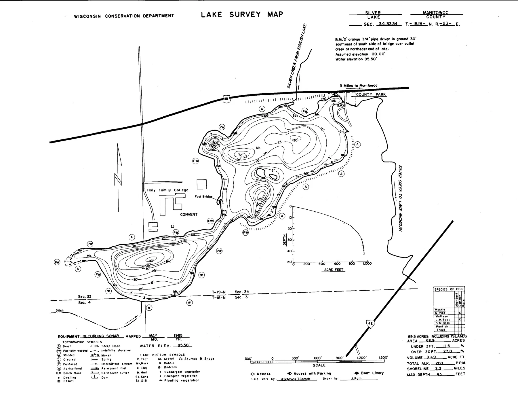
Source: Wisconsin DNR · WBIC 67400 · image navigation only; spatial alignment pending · Historical lake maps are not for navigation.
Source: Wisconsin Department of Natural Resources. Converted for browser access with source URLs, checksums, and retrieval dates retained. Historical lake maps are not for navigation.
73surface acres
43max depth feet
1public access points
44.0697, -87.7343latitude, longitude
Access
Public access points
Boat launchSILVER LAKE BOAT RAMP44.07330, -87.73083Managed by COUNTYTOWN OF MANITOWOC RAPIDSRamp surface: ConcreteADA-accessible feature: NoVerified 2026-07-12
Nearby
Trip-planning places
No nearby trip-planning places yet
Depth FAQ
How deep is Silver Lake?
Silver Lake is 43 feet deep at its deepest point and averages about 16 feet, according to Wisconsin DNR records.
Is there a free depth map of Silver Lake?
Yes. LakeList publishes a free interactive depth contour map of Silver Lake at a typical 5-foot interval, with an optional 3D underwater view, derived from LakeList depth model survey data.
Where does the Silver Lake depth map come from?
The interactive depth contours are derived from LakeList depth model. Each contour set passes a visual QA review against the source document before it is published. The depths are a modeled estimate calibrated to the lake's documented maximum depth - not a survey, and not for navigation.
Trust and freshness
Where this lake data comes from
Wisconsin DNR Lake Mapsname, coordinates, county, source identifiers
LakeList record updated 2026-07-14