LakeList
FavoritesStateWisconsin
Potter Lake
Enhanced dataInteractive depth contours
Potter LakeWalworth County, WI
Contours load with map Access
Interactive depth contours5-foot typical interval · Sonar-derived depth (C-MAP Genesis) · Gaps interpolated · Not for navigation
Source: C-MAP Genesis community sonar (derived)high confidence · QA passed · Select a contour to inspect its mapped depthDepths decoded from C-MAP Genesis Social Map community sonar recordings (used with permission), covering 92% of the lake. Small gaps between recordings are smoothly connected; larger unrecorded areas follow the lake's depth model calibrated to the DNR-documented 26-ft maximum depth. More accurate than a pure model, but still an estimate. Not for navigation.LakeList assistant
Plan your lake day
Fishing spots, food, lodging, marinas, and rentals around Potter Lake.
Start here
Fishing
Fishing at Potter Lake
Fishery
Notable species
Largemouth BassPanfishNorthern Pike
Angler reports · Fishbrain
What anglers catch here
Anglers have logged 117 catches on Potter Lake via Fishbrain — 3 in the last 30 days, most recently on Jul 13, 2026.
Most-reported species
- Largemouth bass
- Northern pike
16 of the 117 logged catches didn’t name a species and aren’t listed above.
Seasonality
All fishOf the 117 logged catches, 90 carry a month and 90 carry a year; the charts cover those.
2020 had the most reports (23).
Counts reflect reporting activity, not fish populations. Waterbody location is provider-level; exact spots and angler details aren’t shown.
Fishery details for this lakeExplore this area on FishbrainWisconsin DNR · 2026–2027 season
Lake-specific fishing regulations
Rule text published by the DNR for this waterbody, cached by WBIC and verified 2026-07-12.
All species
Catch and release fishing for largemouth and smallmouth bass is open year round unless otherwise noted. Motor Trolling is allowed with up to 3 hooks, baits, or lures, per angler.
Catfish
Season Dates: Open All Year. No minimum length limit and the daily bag limit is 10.
Cisco and whitefish
Season Dates: Open All Year. No minimum length limit and the daily bag limit is 10.
Lake sturgeon
Season Dates: Closed. No fishing allowed.
Largemouth and smallmouth bass
Season Dates: May 2, 2026 to March 7, 2027. The minimum length limit is 14" and the daily bag limit is 5.
Muskellunge and hybrids
Season Dates: May 2, 2026 to December 31, 2026 on open water. The minimum length limit is 40" and the daily bag limit is 1.
Northern pike
Season Dates: May 2, 2026 to March 7, 2027. The minimum length limit is 26" and the daily bag limit is 2.
Paddlefish
Season Dates: Closed. No fishing allowed.
Panfish
Season Dates: Open All Year. No minimum length limit and the daily bag limit is 25.
Rock, yellow, and white bass
Season Dates: Open All Year. No minimum length limit and the daily bag limit is unlimited.
Rough fish
Season Dates: Open All Year. No minimum length limit and the daily bag limit is unlimited.
Shovelnose sturgeon
Season Dates: Closed. No fishing allowed.
Trout and salmon
See Trout regulations layer.
Urban waters gamefish
This waterbody is not considered an urban water, Urban Waters Gamefish regulations do not apply.
Walleye, sauger, and hybrids
Season Dates: May 2, 2026 to March 7, 2027. The minimum length limit is 18" and the daily bag limit is 3.
Regulations can change. The official DNR page controls; verify seasons, boundaries, bag limits, and emergency rules before fishing.
NWS weather
Weather windows
Weather-based planning from the National Weather Service hourly forecast near this lake — not a catch forecast.
Loading latest forecast…
Checking wind, precipitation, and near-term weather windows.
Water temperature
Potter Lake water temperature today
Modeled surface-temperature estimate built from seasonal climate, lake depth, and live National Weather Service air temperatures near this lake.
72°FWarm
Seasonal estimate. Checking current National Weather Service air temperatures…
Comfortable summer pattern. Bass and panfish are active; early and late hours beat the midday heat.
Estimates are modeled, not measured. Actual temperatures vary with depth, wind mixing, and recent weather — verify conditions before swimming, boating, or heading onto ice.
Wisconsin DNR water assessment
Impaired waterbody listed
The DNR lists this waterbody as impaired. This notice is not itself a closure; review the official assessment and current guidance before your trip.
303(d) / impairment recordRecreation restrictions noted
High Phosphorus LevelsPollutants: Total Phosphorus
- Status
- TMDL Development
- Public health
- General Advice
- Recreation
- Recreational Restrictions
- Aquatic life
- Not specified
Water is impaired due to one or more pollutants and associated quality impacts.
Review DNR water quality Check consumption advice Source updated 2025-02-10 · LakeList verified 2026-07-12
Official Wisconsin information
Plan with DNR sources
LakeList links to the authoritative record so you can verify maps, rules, and current notices before leaving.
Historical DNR depth maps1 converted map sheetView DNR depth mapHistorical map · not for navigationFishing regulationsVerify current seasons, limits, and restrictionsOfficial DNR lake pageFacts, advisories, boating, and water qualityWater quality reportsMonitoring stations, clarity, and DNR reportsInvasive speciesVerified, observed, and historical AIS recordsBoating ordinancesLocal slow-no-wake and water-use restrictionsFish consumption advisoriesStatewide and waterbody-specific health guidance
Historical depth maps are not for navigation. Verify regulations and access at the official source before your trip.
Historical Wisconsin DNR maps
Potter Lake depth maps
1 converted map sheet. These historical surveys are not for navigation.
Navigable depth map
Potter Lake · sheet 1
Pan, zoom, and inspect the converted Wisconsin DNR historical map image in the browser. Historical survey — not for navigation.
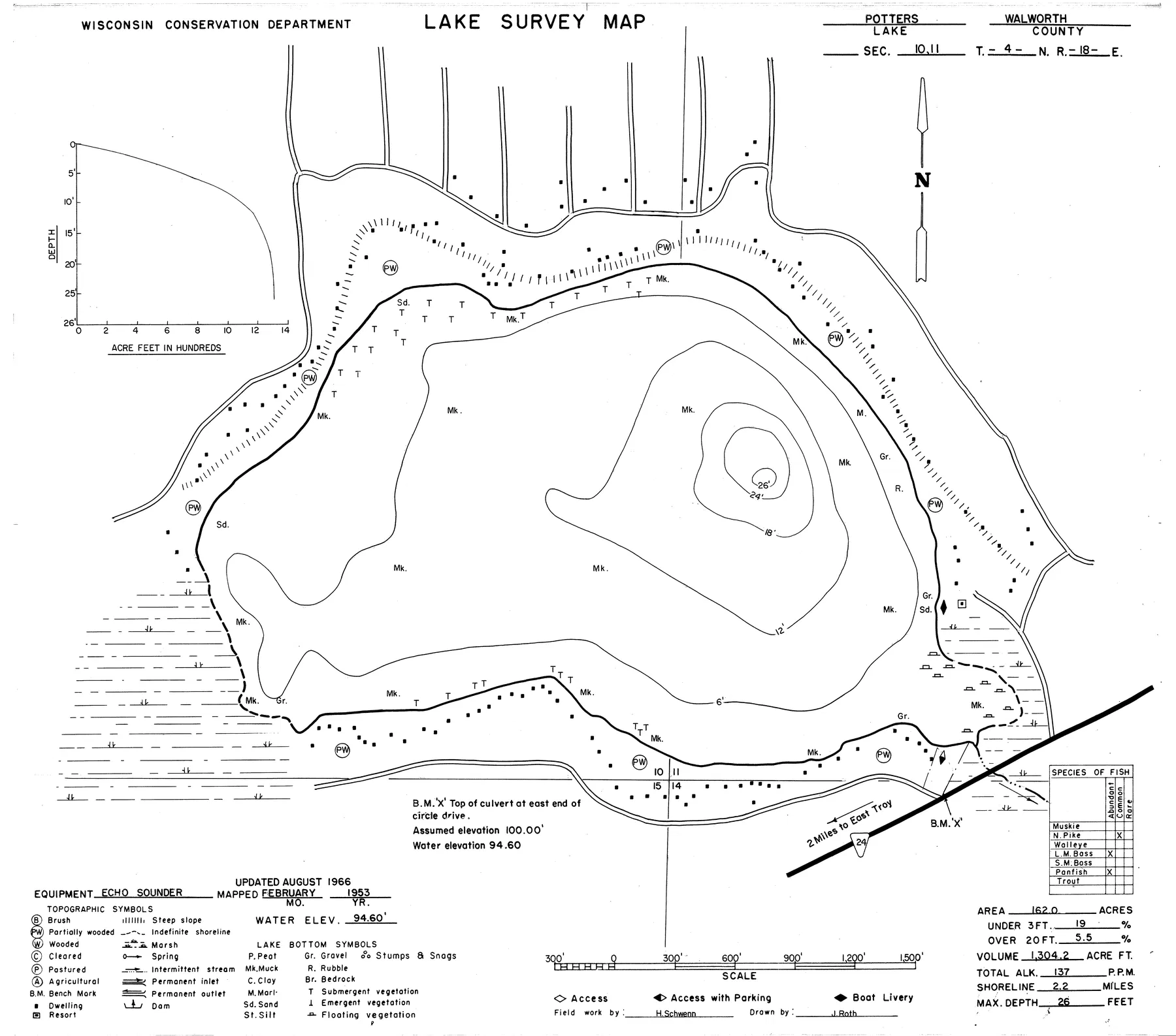
Source: Wisconsin DNR · WBIC 753800 · image navigation only; spatial alignment pending · Historical lake maps are not for navigation.
Source: Wisconsin Department of Natural Resources. Converted for browser access with source URLs, checksums, and retrieval dates retained. Historical lake maps are not for navigation.
155surface acres
26max depth feet
2public access points
42.8172, -88.3483latitude, longitude
Access
Public access points
Boat launchPotter Lake Boat Ramp42.81407, -88.34115Managed by STATE(DNR)TOWN OF EAST TROYRamp surface: Concrete PanelsADA-accessible feature: YesVerified 2026-07-12
Boat launchPotter Lake Public Access42.81407, -88.34115Managed by STATE(DNR)Select One...Ramp surface: ConcreteADA-accessible feature: YesVerified 2026-07-12
Nearby
Trip-planning places
No nearby trip-planning places yet
Depth FAQ
How deep is Potter Lake?
Potter Lake is 26 feet deep at its deepest point and averages about 8 feet, according to Wisconsin DNR records.
Is there a free depth map of Potter Lake?
Yes. LakeList publishes a free interactive depth contour map of Potter Lake at a typical 5-foot interval, with an optional 3D underwater view, derived from C-MAP Genesis community sonar (derived) survey data.
Where does the Potter Lake depth map come from?
The interactive depth contours are derived from C-MAP Genesis community sonar (derived). Each contour set passes a visual QA review against the source document before it is published. The depths are derived from community sonar recordings (C-MAP Genesis Social Map, used with permission), with gaps between recordings interpolated; not for navigation.
Trust and freshness
Where this lake data comes from
Wisconsin DNR Lake Mapsname, coordinates, county, source identifiers
LakeList record updated 2026-07-14
Keep exploring