LakeList
FavoritesStateWisconsin
Minocqua Lake
Minocqua LakeOneida County, WI
Contours load with map Access
Interactive depth contours5-foot typical interval · Sonar-derived depth (C-MAP Genesis) · Gaps interpolated · Not for navigation
Source: C-MAP Genesis community sonar (derived)high confidence · QA passed · Select a contour to inspect its mapped depthDepths decoded from C-MAP Genesis Social Map community sonar recordings (used with permission), covering 58% of the lake. Small gaps between recordings are smoothly connected; larger unrecorded areas follow the lake's depth model calibrated to the DNR-documented 60-ft maximum depth. More accurate than a pure model, but still an estimate. Not for navigation.LakeList assistant
Plan your lake day
Fishing spots, food, lodging, marinas, and rentals around Minocqua Lake.
Start here
Fishing
Fishing at Minocqua Lake
Fishery
Notable species
Largemouth BassMuskyPanfishWalleyeNorthern PikeSmallmouth Bass
Angler reports · Fishbrain
What anglers catch here
Anglers have logged 433 catches on Minocqua Lake via Fishbrain — 3 in the last 30 days, most recently on Jul 26, 2026.
Most-reported species
- Largemouth bass
- Northern pike
- Bluegill
- Black crappie
- Walleye
- Rock bass
Show 6 more species
- Smallmouth bass
- Yellow perch
- Muskellunge
- Bowfin reported as “Eyetail bowfin”
- Pumpkinseed
- Tiger muskellunge
25 of the 433 logged catches didn’t name a species and aren’t listed above.
Seasonality
All fishOf the 433 logged catches, 365 carry a month and 339 carry a year; the charts cover those.
2019 had the most reports (57).
Counts reflect reporting activity, not fish populations. Waterbody location is provider-level; exact spots and angler details aren’t shown.
Fishery details for this lakeExplore this area on FishbrainWisconsin DNR fisheries survey
Fish population survey
Structured LakeList extraction from the 2024 DNR fisheries survey. Population estimates, density, and catch-rate indices use different units, methods, and scopes, so each value is presented in its original form rather than normalized against a different measure.
Survey indicatorsValues keep their source unit and method; unlike measures are not scaled or compared.
Management contextLake-specific 2024 spring community electrofishing and adult-walleye mark-recapture assessment.
DNR documented abundant bluegill, low black-crappie catch, quality largemouth-bass size potential, limited smallmouth-bass catch, and an estimated 3,880 adult walleyes.
- The smallmouth-bass paragraph labels a preferred-size rate per net-night despite describing electrofishing; that unit-conflicted value is excluded.
- Counts, CPUE and lengths are retained exactly as printed without deriving effort from their ratios.
- Historical comparisons and qualitative percentile classifications are excluded.
Black crappie
7 fishTotal captured · p. 14.7 fish/mileSurvey CPUE · p. 12.5 inchesminimum captured length · p. 111.2 inchesmaximum captured length · p. 1
Bluegill
185 fishTotal captured · p. 2123.3 fish/mileSurvey CPUE · p. 22.9 inchesminimum captured length · p. 28.4 inchesmaximum captured length · p. 2
Largemouth bass
70 fishTotal captured · p. 26.6 fish/mileSurvey CPUE · p. 27.3 inchesminimum captured length · p. 220.1 inchesmaximum captured length · p. 2
Pumpkinseed
20 fishTotal captured · p. 313.3 fish/mileSurvey CPUE · p. 35 inchesminimum captured length · p. 37.5 inchesmaximum captured length · p. 3
Smallmouth bass
20 fishTotal captured · p. 31.9 fish/mileSurvey CPUE · p. 36.5 inchesminimum captured length · p. 314.2 inchesmaximum captured length · p. 3
Walleye
1,464 fishTotal captured · p. 45.7 inchesminimum captured length · p. 430 inchesmaximum captured length · p. 43,880 adult fishAdult population estimate · p. 4
2024 Fishery Snapshot: Minocqua Lake, Oneida CountyMatched by exact wbic name county · WBICs 1542400 · verified 2026-07-19Wisconsin DNR fisheries survey report; LakeList operator documented permission to leverage this report with source attribution.
Wisconsin DNR stocking
Fish stocking history
The latest published year is 2025, when 13,601 fish were recorded across 2 entries.
2025
MuskellungeUpper Wisconsin River · Large Fingerling
26111.2 in average
2025
WalleyeUpper Wisconsin River · Large Fingerling
13,3406.5 in average
2024
WalleyeUpper Wisconsin River · Egg
522,500Length not listed
2024
WalleyeUpper Wisconsin River · Fry
3,900,0001.0 in average
2023
MuskellungeUpper Wisconsin River · Large Fingerling
33411.0 in average
2023
WalleyeUpper Wisconsin River · Egg
76,848Length not listed
2023
WalleyeUpper Wisconsin River · Fry
3,200,0001.0 in average
2023
WalleyeUpper Wisconsin River · Large Fingerling
13,3766.3 in average
2022
WalleyeUpper Wisconsin River · Fry
2,000,0000.5 in average
2021
MuskellungeUpper Wisconsin River · Large Fingerling
34912.1 in average
2021
WalleyeMississippi Headwaters · Large Fingerling
13,3697.1 in average
2019
MuskellungeUpper Wisconsin River · Large Fingerling
83911.2 in average
Showing the 12 most recent records from 21 published entries.
NWS weather
Weather windows
Weather-based planning from the National Weather Service hourly forecast near this lake — not a catch forecast.
Loading latest forecast…
Checking wind, precipitation, and near-term weather windows.
Water temperature
Minocqua Lake water temperature today
Modeled surface-temperature estimate built from seasonal climate, lake depth, and live National Weather Service air temperatures near this lake.
68°FWarm
Seasonal estimate. Checking current National Weather Service air temperatures…
Comfortable summer pattern. Bass and panfish are active; early and late hours beat the midday heat.
Estimates are modeled, not measured. Actual temperatures vary with depth, wind mixing, and recent weather — verify conditions before swimming, boating, or heading onto ice.
DNR water check
Water quality quick take
Historical volunteer-monitoring record for this lake.
Last sampled date unknown
Individual readings are not retained for this lake — the index below is what the monitoring record summarizes.
44 five-year summer trophic state index · Mesotrophic. Moderately clear with moderate nutrients — some algae and plant growth through the season.
Minocqua Lake - Center BasinStation 443134 · TSI based on chlorophyll
Historical record only — no current water-quality data exists for this lake. LakeList verified 2026-07-12.Lake of the Week No. 1
Dragon boats Aug 15, the season's last ski show Aug 16, then the Aqua Bowl is a park again
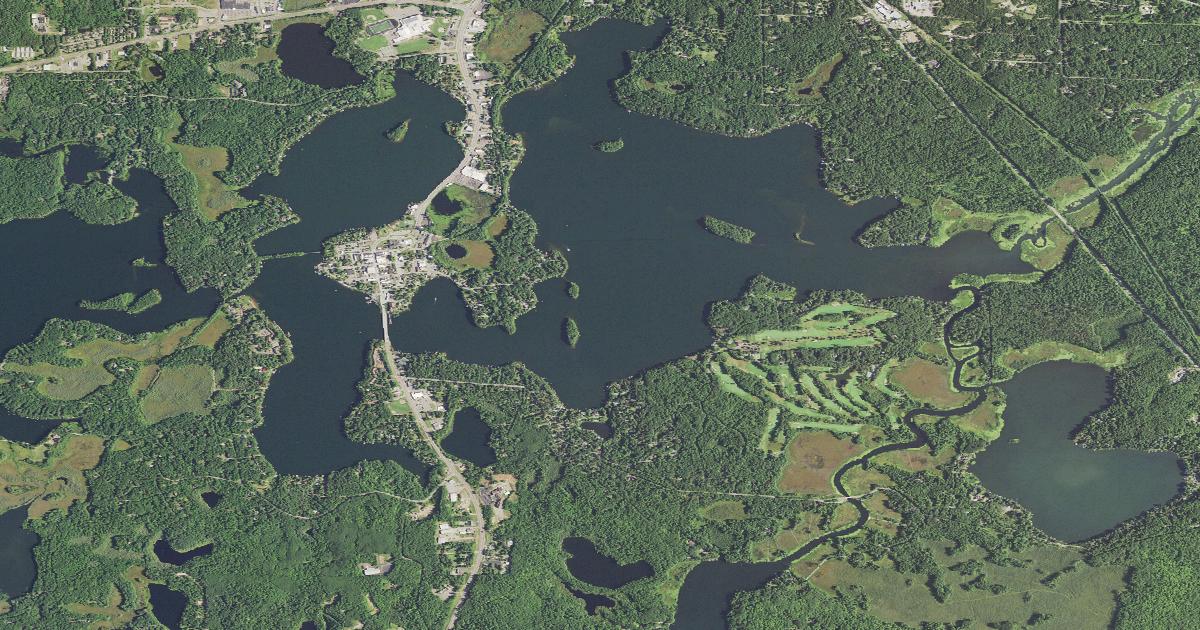
The Min-Aqua Bats close their 2026 season on Minocqua Lake on Sunday, August 16; the tenth Minocqua Dragon Boat Festival runs off Torpy Park the day before — organizers' own dates, checked August 1. The lake underneath keeps a slower calendar.
What the 2024 survey measured, what the old depth sheet still shows, the four launch records, what to plan around, and one official page whose rules have gone stale.
What the record says
Crews handled 1,464 walleye during the 2024 DNR spring survey, 5.7 to 30.0 inches, and worked that up to an estimated 3,880 adults. The 3,880 is a mark-recapture estimate; the 1,464 is what crews actually put hands on. The same survey's late-spring electrofishing logged 123.3 bluegill per mile and 6.6 largemouth per mile — gear- and effort-specific catch rates, not population estimates. The DNR stocked 13,340 large walleye fingerlings the next year, averaging 6.5 inches, and 2025 is where the stocking record stops.
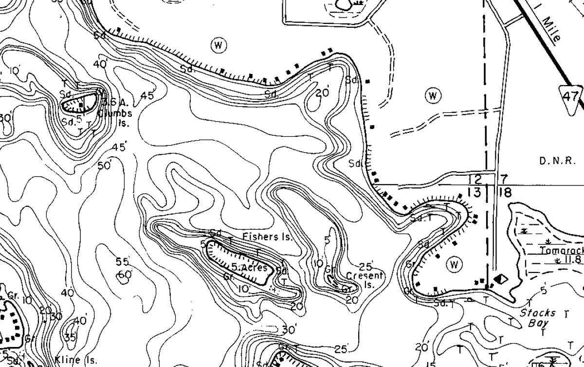
The July 1972 depth sheet adds the shape of the container: 55 percent of this basin sits deeper than 20 feet and 6 percent shallower than three, 31,765 acre-feet inside 15.68 miles of shoreline. It labels School House Bay, Huber Bay, Kennedy Bay and Stacks Bay, plus Fishers, Clumbs, Kline, Jossart and Cresent islands — 1972's labels, not current usage. Two still ride on launches: Stacks Bay on the DNR landing, School House Bay on the town's Schoolhouse Bay ramp. The interactive contours on this page come from community sonar recordings — an estimate, not survey linework. The 1972 sheet is still the newest agency depth survey in our record.
Getting on the water
Surface and an ADA flag are all our four public launch records give you to choose on, and all four were matched against the DNR boat-access layer when we last read it, July 12, 2026. Chicago Avenue and Park Street are paved and flagged ADA-accessible, with nothing in the record to separate them; Stacks Bay is paved without the flag; Cedar Street is gravel. The Town of Minocqua separately prices three town-owned ramps here at $10 daily, April 1 through November 30, by QR code now rather than the old drop box.
If you go
Torpy Park Do — Four waterfront acres on the same island as the downtown strip: beach, restrooms, playground, tennis and sand volleyball courts, picnic shelters with grills. In winter it becomes an ice skating rink. The town warns in capitals that there are no lifeguards on duty. (Town of Minocqua) 705 Oneida St.
The Bearskin State Trail Do — Compacted granite, 21.5 miles from downtown toward Tomahawk, laid on the rail corridor the DNR describes as built to move white pine out of these forests. Thirteen trestles cross the water along it. Walking is free; riding is not. Bicyclists 16 and older need a state trail pass: $5 daily, $25 annual in 2026. (Wisconsin DNR)
The Thirsty Whale Eat — It started as a 1902 boat livery and still stands entirely over the water, by the restaurant's own account. Wisconsin barred new boathouses beyond the ordinary high-water mark after December 16, 1979 (Wis. Stat. 30.121(2)); this one predates that line by 77 years. Its own site lists the kitchen Wednesday through Sunday, 11:30 a.m. to 8 p.m., and until 9 on Fridays. (The Thirsty Whale) 453 W. Park Ave.
Island Cafe Eat — Breakfast and lunch, from a cafe whose own name dates it to 1957. Four days a week is the catch, so a downtown breakfast is worth checking the night before. Thursday through Sunday, 7 a.m. to 2 p.m.; closed Monday through Wednesday. (Island Cafe) 314 Oneida St.
Straight talk
The DNR's own Minocqua Chain page still describes a walleye regulation "planned for 2025" and running "through May 2025." Its acreages hold up; its rules have gone stale, so check the current regulations before you keep a fish. (Minocqua Chain page, current DNR regulations)
Editorial claims, not measurements. Facts checked August 1, 2026 — hours and schedules change, and the source links are the tiebreaker.
Aerial: USDA NAIP via USGS (Public domain) · Map: Wisconsin DNR lake survey sheet, July 1972 (Public record)
Read the full story: 9 Ways to Spend a Day on Lake MinocquaAll Lake of the Week editionsLakeList on Facebook
Official Wisconsin information
Plan with DNR sources
LakeList links to the authoritative record so you can verify maps, rules, and current notices before leaving.
Historical DNR depth maps1 converted map sheetView DNR depth mapHistorical map · not for navigationFishing regulationsVerify current seasons, limits, and restrictionsOfficial DNR lake pageFacts, advisories, boating, and water qualityWater quality reportsMonitoring stations, clarity, and DNR reportsInvasive speciesVerified, observed, and historical AIS recordsBoating ordinancesLocal slow-no-wake and water-use restrictionsFish consumption advisoriesStatewide and waterbody-specific health guidance
Historical depth maps are not for navigation. Verify regulations and access at the official source before your trip.
Historical Wisconsin DNR maps
Minocqua Lake depth maps
1 converted map sheet. These historical surveys are not for navigation.
Navigable depth map
Minocqua Lake · sheet 1
Pan, zoom, and inspect the converted Wisconsin DNR historical map image in the browser. Historical survey — not for navigation.
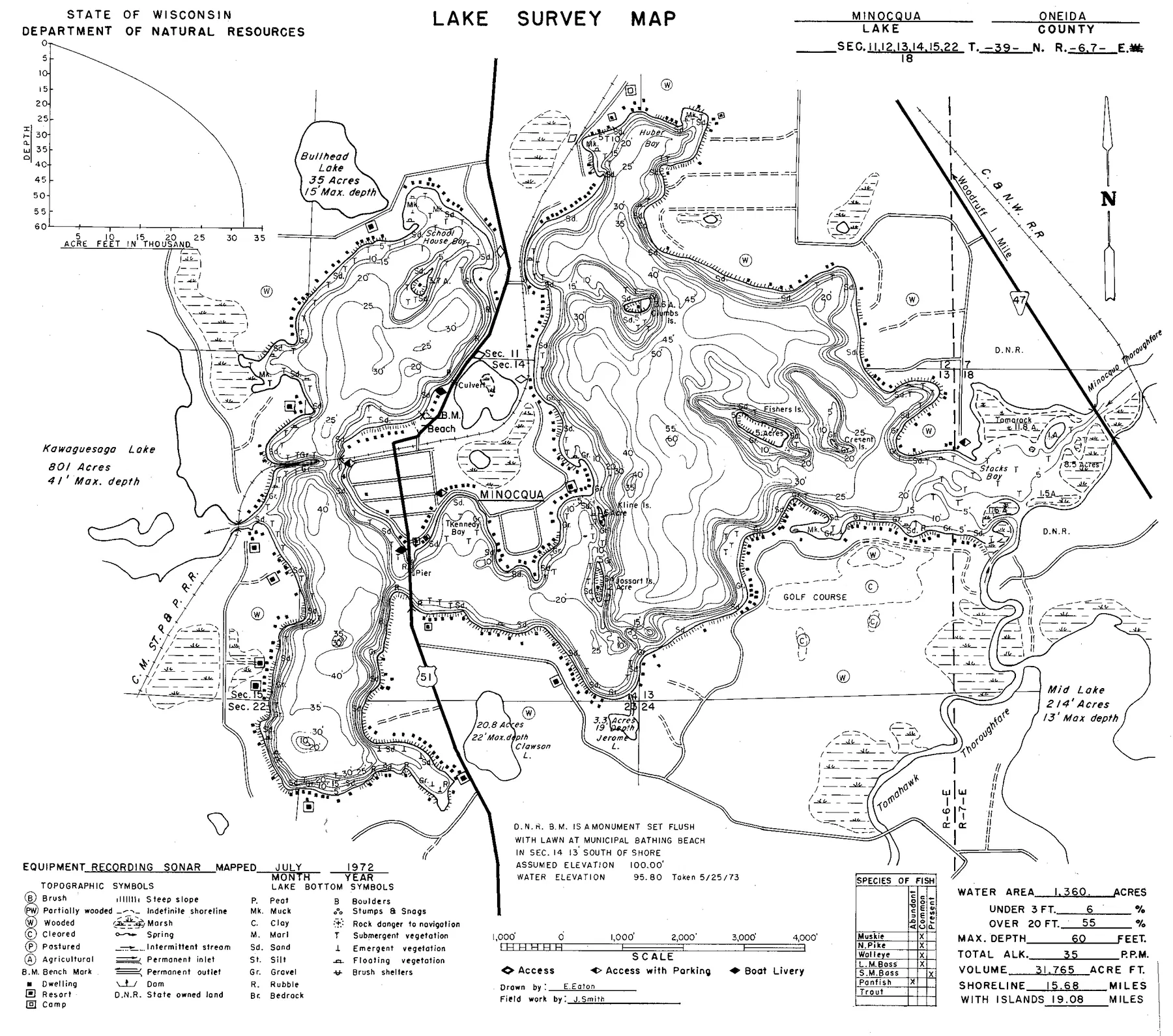
Source: Wisconsin DNR · WBIC 1542400 · image navigation only; spatial alignment pending · Historical lake maps are not for navigation.
Source: Wisconsin Department of Natural Resources. Converted for browser access with source URLs, checksums, and retrieval dates retained. Historical lake maps are not for navigation.
1,339surface acres
60max depth feet
4public access points
45.8716, -89.6837latitude, longitude
Access
Public access points
Boat launchCedar Street Ramp45.87428, -89.70096Managed by TOWNSHIPTOWN OF MINOCQUARamp surface: GravelADA-accessible feature: NoVerified 2026-07-12
Boat launchChicago Avenue Access45.86985, -89.70592Managed by TOWNSHIPTOWN OF MINOCQUARamp surface: PavedADA-accessible feature: YesVerified 2026-07-12
Boat launchPark Street Access45.87036, -89.71372Managed by TOWNSHIPTOWN OF MINOCQUARamp surface: PavedADA-accessible feature: YesVerified 2026-07-12
Boat launchStacks Bay Landing45.87202, -89.67343Managed by STATE(DNR)TOWN OF WOODRUFFRamp surface: PavedADA-accessible feature: NoVerified 2026-07-12
Nearby
Trip-planning places
No nearby trip-planning places yet
Depth FAQ
How deep is Minocqua Lake?
Minocqua Lake is 60 feet deep at its deepest point and averages about 23 feet, according to Wisconsin DNR records.
Is there a free depth map of Minocqua Lake?
Yes. LakeList publishes a free interactive depth contour map of Minocqua Lake at a typical 5-foot interval, with an optional 3D underwater view, derived from C-MAP Genesis community sonar (derived) survey data.
Where does the Minocqua Lake depth map come from?
The interactive depth contours are derived from C-MAP Genesis community sonar (derived). Each contour set passes a visual QA review against the source document before it is published. The depths are derived from community sonar recordings (C-MAP Genesis Social Map, used with permission), with gaps between recordings interpolated; not for navigation.
Trust and freshness
Where this lake data comes from
Wisconsin DNR Lake Mapsname, coordinates, county, source identifiers
LakeList record updated 2026-07-12
Keep exploring